The FAA announced the registration requirement earlier this month and launched the site on Monday, hoping to get up and running before the holiday rush. If you buy or receive a drone this holiday season, make sure you're flying it legally.
What happens if you don't register?
Criminal penalties for flying a drone without registering are up to three years in jail, or up to $250,000 in fines. The agency is unlikely to dedicate many resources into enforcing the registration rule at first. Local law enforcement will handle the bulk of enforcement for now.
Any other rules you should know?
Once you're registered, you can take your new drone out for a spin. As long as you follow all the rules. Most importantly, don't fly the drone above 400 feet (the height of a 30 to 40 story building), never let it out of your eyesight, and don't fly it near airports or populated areas like stadiums.
How do you register?
Registration is $5 for three years and can be done online at RegisterMyUAS.faa.gov. Drone owners give the FAA their full name, physical and mailing addresses, and an email address. The FAA is waiving the fee for one month. People who bought a drone before December 21 have until February 19 to register.
Part of Alaska's allure is melting. But it's not all bad news for the 49th state's glaciers. While most of the more than 100,000 glaciers in Alaska are thinning, retreating or stagnating, Johns Hopkins and Margerie glaciers are actually advancing, fed by abundant snowfall from the Fairweather Range.
These are just two of the icy wonders in the 3.3 million-acre Glacier Bay National Park in southeast Alaska. The last of the bay's four glacial periods began about 4,000 years ago, leaving today's glaciers in its wake.
Take a sea kayaking trip out of park headquarters at Bartlett Cove to get a closer look at these icy Alaskan phenomena, or see the wild expanse from above on a flight seeing expedition. If you're lucky, you'll see a moose or bear swimming across the bay.
* January 18 – Martin Luther King, Jr. Day
* April 16 through 24 – National Park Week
* August 25 through 28 – National Park Service Birthday (and following weekend)
* September 24 – National Public Lands Day
* November 11 – Veterans Day
“Fee-free days provide an extra incentive to visit a national park, especially during next year’s centennial celebration,” said National Park Service Director Jon B. Jarvis. “We added extra fee-free days so that everyone has a chance to join the party. With locations in every state, finding a national park is easy. The hard part might be deciding which ones to visit.”
America The Beautiful - The National Parks and Federal Recreational Lands Pass http://ow.ly/VOzuk
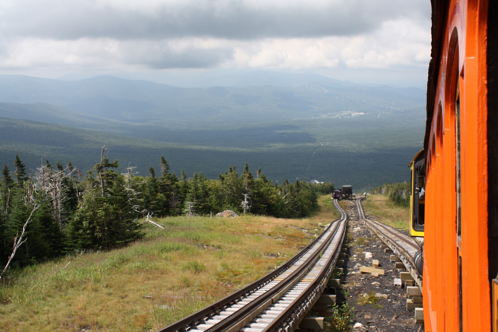
The average temperature on the summit is 26.5 degrees Fahrenheit (-3 C), winds average 35.3 miles per hour (56.8 kmh). The summit gets about 42 feet of snow per year, and typically sees snowfall every month of the year -- though it melts quickly in the summer.
In April 1934, the observatory recorded a 231-mile-per-hour (372 kmh) wind that remains a world record for a land-based weather station. Some of the observatory buildings are secured to the summit with chains to keep them from blowing away. Temperatures atop the mountain can drop as low as -47 degrees Fahrenheit (-44 C)
On the clearest days, observers can see as far as Mount Marcy in New York State, 134 miles to the west.
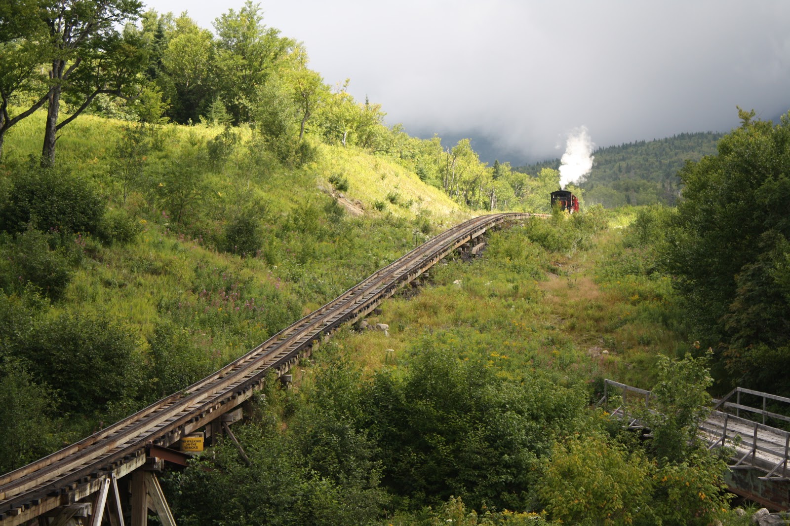
Just The Facts.... 1.The Mount Washington Cog Railway was the first mountain climbing cog railway in the world. 2.The Mount Washington Cog Railway was created and designed by Sylvester Marsh of Campton, New Hampshire. 3.The first locomotive, Old Peppersass, so named because it resembled an old pepper sauce bottle, reached the summit of Mount Washington on July 3, 1869. Today it is on display at the base station. 4.Jacob's Ladder is the steepest section of the Cog's trestle, with a 37% grade. This means that there is an elevation difference of 13 feet between passengers in the front and back of the coach! 5.Each trip to the summit on the Cog Railway uses 1 ton of coal, and 1,000 gallons of water. 6.The Mount Washington Cog Railway was named a National Historic Engineering Landmark on June 26, 1976. 7.Mount Washington is the highest summit in the northeastern part of the U.S. - elevation 6,288-feet. 8.Darby Field of Exeter, New Hampshire, was the first man known to have reached the mighty summit of Mount Washington in 1642. Indian legend stated that the summit was home to the Great Spirit and death would come to any human who ascended the peak. 9.The oldest building on the summit is the Tip Top House, built in 1853. 10.The Lake of the Clouds is said to be the highest body of water in the eastern part of the United States. 11.The average annual snowfall on the summit of Mount Washington is 177 inches. 12.A continental ice sheet once covered Mount Washington, and there is permanently frozen ground just beneath the summit. 13.The lowest recorded temperature at the summit was -49 degrees Fahrenheit; the highest was +74 degrees. The temperature on the summit falls below zero more than 65 days a year. 14.The average annual wind velocity at the summit is 37 mph. The highest wind velocity ever recorded in the world was at the summit of Mount Washington in April 1934 - at 231 mph! (Source: The Mount Washington Cog Railway http://ow.ly/VO0mU)
Busy Day at the summit today it was "Race to the Top Bike Challenge" Road Race Day today. The oldest building on the summit is the Tip Top House, built in 1853
The Mount Washington Observatory has been staffed continuously since 1932, with the exception of a brief evacuation in February 2004 due to a fire.
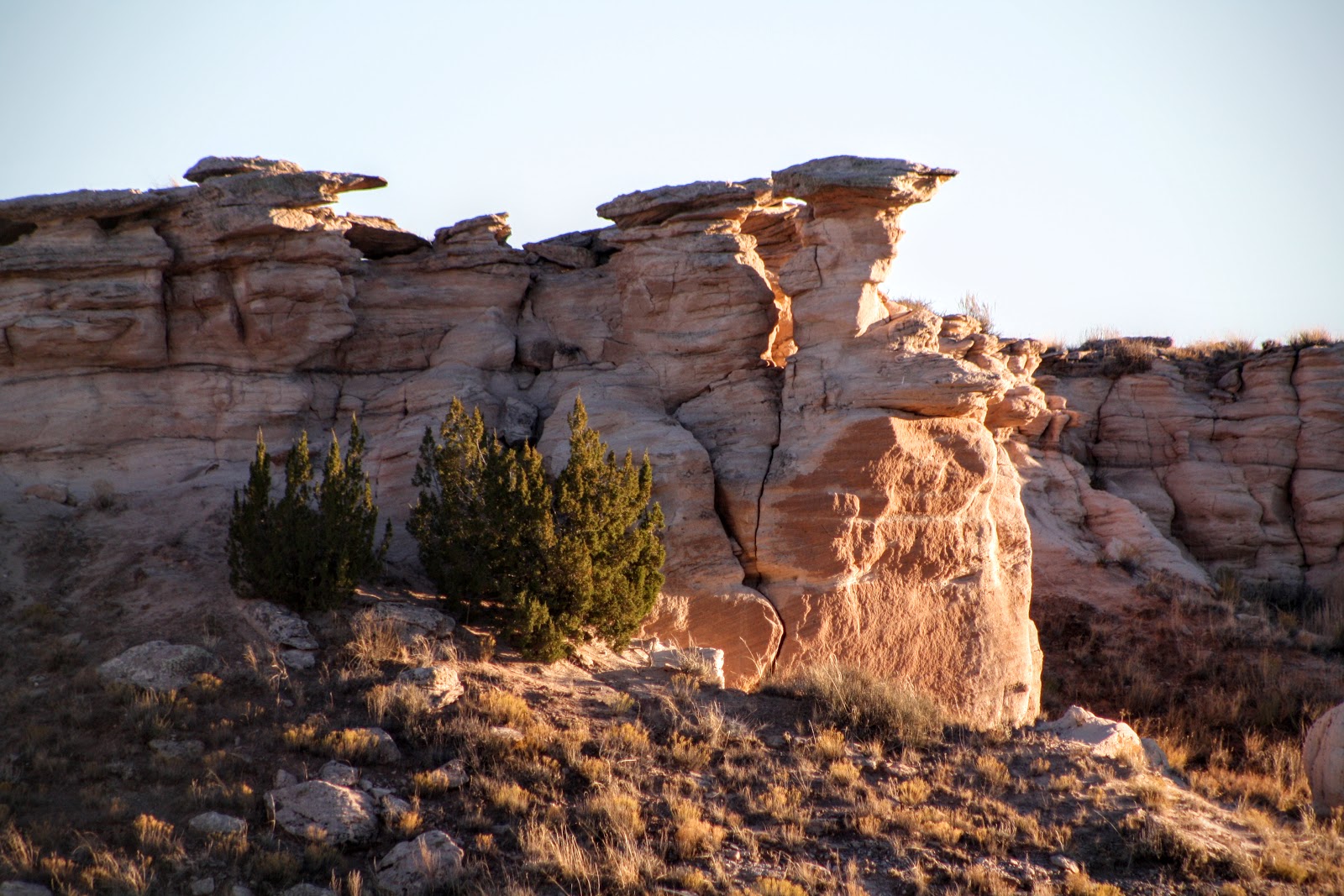
Petrified Forest National Park is a United States national park in Navajo and Apache counties in northeastern Arizona. Named for its large deposits of petrified wood, the fee area of the park covers about 170 square miles (440 square kilometers), encompassing semi-desert shrub steppe as well as highly eroded and colorful badlands. The park's headquarters is about 26 miles (42 km) east of Holbrook along Interstate 40 (I-40), which parallels the BNSF Railway's Southern Transcon, the Puerco River, and historic U.S. Route 66, all crossing the park roughly east–west. The site, the northern part of which extends into the Painted Desert, was declared a national monument in 1906 and a national park in 1962. About 800,000 people visit the park each year and take part in activities including sightseeing, photography, hiking, and backpacking.
Averaging about 5,400 feet (1,600 m) in elevation, the park has a dry windy climate with temperatures that vary from summer highs of about 100 °F (38 °C) to winter lows well below freezing. More than 400 species of plants, dominated by grasses such as bunchgrass, blue grama, and sacaton, are found in the park. Fauna include larger animals such as pronghorns, coyotes, and bobcats; many smaller animals, such as deer mice; snakes; lizards; seven kinds of amphibians, and more than 200 species of birds, some of which are permanent residents and many of which are migratory. About half of the park is designated wilderness.
The Petrified Forest is known for its fossils, especially fallen trees that lived in the Late Triassic, about 225 million years ago. The sediments containing the fossil logs are part of the widespread and colorful Chinle Formation, from which the Painted Desert gets its name. Beginning about 60 million years ago, the Colorado Plateau, of which the park is part, was pushed upward by tectonic forces and exposed to increased erosion. All of the park's rock layers above the Chinle, except geologically recent ones found in parts of the park, have been removed by wind and water. In addition to petrified logs, fossils found in the park have included Late Triassic ferns, cycads, ginkgoes, and many other plants as well as fauna including giant reptiles called phytosaurs, large amphibians, and early dinosaurs. Paleontologists have been unearthing and studying the park's fossils since the early 20th century.
The park's earliest human inhabitants arrived at least 8,000 years ago. By about 2,000 years ago, they were growing corn in the area and shortly thereafter building pit houses in what would become the park. Later inhabitants built above-ground dwellings called pueblos. Although a changing climate caused the last of the park's pueblos to be abandoned by about 1400 CE, more than 600 archeological sites, including petroglyphs, have been discovered in the park. In the 16th century, Spanish explorers visited the area, and by the mid-19th century a U.S. team had surveyed an east–west route through the area where the park is now located and noted the petrified wood. Later, roads and a railway followed similar routes and gave rise to tourism and, before the park was protected, to large-scale removal of fossils. Theft of petrified wood remains a problem in the 21st century. (Soruce: Wikipedia, the free encyclopedia http://ow.ly/VIAkl)